Terraquest’s Resolution™ Airborne Magnetics
Airborne magnetic surveying is a geophysical method used to image anomalies in the earth's magnetic field caused by variations in the magnetization of the crust. These variations may be indicative of structural or lithological contrasts in the subsurface.
Magnetic data can be collected on the earth's surface, from the air, at sea, or in a borehole. This information can be used by exploration geophysicists in their search for mineral-bearing ore bodies or hydrocarbon-bearing sedimentary structures, or by archaeologists searching for buried artifacts.
Of the two types of magnetometers, vector and scalar, Terraquest excels in scalar magnetics which determines the total strength of a magnetic field.
Moreover, the company combines these scalar devices in arrays comprising two or three magnetometers to generate magnetic gradiometer data (either horizontal or vertical). Click the link to learn more about Terraquest’s Horizon™ horizontal gradient Survey.

High Resolution™ Magnetics (top) overlying Gravity (middle) and Lidar (bottom).
Terraquest can easily perform multiple surveys and integrate disparate types of data into a consistent result.
Benefits
There are a number of benefits to Terraquest’s airborne magnetic surveys:
- High resolution survey capable for precious and base metals, and hydrocarbon exploration.
- Stable survey platform – essential for acquiring high resolution magnetic data.
- Experience in survey design and processing (for more details, see Case Histories).
Terraquest is truly a high performance operator as case history results show as well.
Applications
Terraquest’s clients for Resolution™ magnetic surveys are precious metal explorers seeking to examine shear and lithologic fabrics and contacts as well as base metal explorers using direct magnetic detection for iron ore. In addition, airborne magnetic surveys are flown in hydrocarbon exploration applications for comparison and joint interpretation with the results from Terraquest’s Equilibrium Gravity™ Survey.
Case Histories and Reference Information
HydrocarbonFor More Information
Terraquest would be pleased to discuss airborne magnetic surveys and interpretation for Resolution™ Magnetic surveys and approaches with you, click below.
Terraquest’s Horizon™ (Horizontal Gradiometer) Airborne Magnetics
Magnetic gradiometer surveys have long been an application for mineral exploration surveys, particularly for near surface targets.
An original configuration is the vertical gradiometer which “pre-conditions” the survey to shallow depths. However, Terraquest flies the Horizon™ airborne horizontal gradient survey for a variety of other reasons, including to provide the highest and most accurate targeting – which is only possible through sensitive gradiometric measurements -- in many cases.
Survey technique is also a key consideration in planning these surveys, and Terraquest begins by careful survey planning; calibration of systems; and then, data acquisition, processing, and interpretation. The configuration of the airborne geophysical survey platform is shown below -- with two wing-tip pods representing the housings for each side of the horizontal gradient array (and a third pod on the tail – not shown).
Terraquest’s-Cessna 206 aircraft with Horizon™ Grad set up and wing tip pods on each tip of the wings and the tail.
Terraquest is a master in ultra-slow and low flying as required for better data and results from this method.
Deliverables
In addition to magnetic products derived independently from each sensor, Terraquest provides a complete range of deliverables including high resolution Horizontal Gradient Vector Images, such as the one shown below.
Terraquest Ltd. is able to provide updated preliminary map images within 48 hours of acquisition.
Plan map showing Horizontal Gradient Vectors overlaid on magnetic data. Magnetic data show a target on the line; Horizon™ Grad data show the true target for drilling is between lines.
Benefits
The main advantage of Terraquest’s Horizon™ airborne horizontal gradiometer survey is that it paves the way for enhanced resolution through improved gridding and contouring (gives data both on and between the lines; more information in general). Explorers can also benefit from higher precision in locating small anomalies between flight lines and also in locating faults, dykes, and contacts more accurately.
Other benefits are specifically focused on the geologists, including defining magnetic axes within magnetic units, defining the dip of units, and distinguishing between culture and small geological signals, such as those from kimberlites.
Applications
Airborne horizontal gradient surveys are best utilized where targets are shallow and where high resolution and drill targeting ability are required. Natural application fits include kimberlite exploration.
Case Histories and Reference Information
Kimberlite targeting case history
Technical Considerations
For explorers interested in technologies associated with the Horizon™ airborne horizontal gradient survey, the system is based upon three latest-technology cesium vapour sensors, mounted on extensions from each wing tip and tail.
The sensors give a 0.005 nT sensitivity with recording at 10 to 20 times per second for high density coverage. Noise is constrained through a +/- 0.02 nT fourth difference noise envelope.
In terms of data acquisition and navigation, Terraquest uses AGIS and SDAS fully integrated data acquisition systems with real time corrected GPS. Also included is digital video flight path confirmation at 1/10 second with fiducial and GPS location registration over print. Radar and Barometric altimeter data are simultaneously recorded.
For More Information
Terraquest would be pleased to discuss Horizon™ airborne horizontal gradient surveys and interpretation approaches with you, including inversions of existing or planned data. For more information, click below.
Terraquest’s Matrix™ VLF EM – Near Surface Detection of Key Targets
VLF-EM is a geophysical prospecting method that was a mainstay of exploration during the 1970’s through 1990’s. Its popularity declined somewhat with the advent of high-powered, deep imaging time domain electromagnetic surveys.
However, VLF-EM still has a valuable role to play in exploration, particularly in diamond and gold exploration as shown in the implementation of Terraquest’s Matrix™ airborne VLF surveys. A case history presented later shows this survey in action with a kimberlite deposit situated in Northern Alberta, Canada. A separate gold case history is provided as well.
The basic premise of Terraquest’s Matrix™ airborne VLF-EM survey is the use of ultra-low frequency electromagnetic waves emanating from ground-based navigation stations. These waves penetrate the near surface of the ground, making them an ideal tool for shallow exploration.

Terraquest test data showing magnetics at top and Matrix™ VLF-EM results at bottom. The VLF-EM data shows three directions for conductors located to the west, centre and east of the map.
Terraquest offers surveys based on the advanced Matrix™ Digital VLF-EM frequency system that was designed and built by Dr. Petr Kuzmin of Magenta Geophysics Ltd. at Terraquest’s request.
The Matrix™ VLF-EM system is a modern, light weight, digital, passive system that utilizes continent-wide communication VLF radio signals as a power source to energize ground conductors. Signals are received on three axis by 3 orthogonal coils and recorded independently from up to four VLF stations.


Digital power and acquisition system and Matrix™ 3-axis VLF-EM sensor.
Some of the system characteristics are shown below:

Operating characteristics of the Matrix™ airborne VLF-EM system used in Terraquest’s airborne geophysical surveys.
Deliverables
With the results being fully digital, Terraquest is able to deliver a full range of products, including vertical and planar ellipticities, conductor amplitude total field peak detection, tilt, and azimuth to the transmitter separately for each frequency.
Benefits
For explorers, the benefits of Matrix™ VLF-EM that contribute to Terraquest’s high quality data acquisition including high resolution data from state-of-the-art-circuitry; isolation of data from three coils so that data is cleaner; and simultaneous monitoring of up to 4 independent and customizable VLF frequencies -- meaning that full advantage of source-target coupling geometries can be achieved. Other tangible benefits from Terraquest’s airborne VLF surveys include:
- Full parameterization of anomalous VLF-EM signals – including angular and ellipticity components – for maximum flexibility for integration and advanced modeling and interpretation.
- The proven effectiveness of VLF-EM technology in mapping structure effectively and economically, to unravel structural complexities.
- Ability to map fine-grain, low conductivity, and more disseminated structures.
- Low cost alternative to deeper seeking active EM systems.
Applications
Terraquest’s clients for Matrix™ VLF-EM airborne geophysical surveys are diamond and gold explorers seeking answers to questions of shallow or complex shallow geology (faults and shears) at minimal cost. It is also effective for base metals near surface and is a natural complement to magnetic surveys.
Case Histories and Reference Information
Kimberlite targeting case history
Gold targeting case history
VLF Stations
For More Information
Terraquest would be pleased to discuss Matrix™ airborne VLF-EM surveys and interpretation approaches with you, including inversions of existing or planned data. For more information, click below.
Terraquest’s Max-Gamma™ Airborne Radiometrics
In earth science exploration, one of the parameters of interest is natural radioactivity and mapping of this natural radioactivity.
Ambient radioactivity is commonly associated with three isotopes, including potassium, uranium, and thorium. It is the mapping of these for comparison and ratioing that is the objective of an airborne radiometric survey.
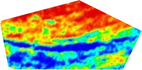
Image of Total Count Radiometric Data Acquired by Terraquest’s Max-Gamma™ airborne radiometric survey. This high resolution result is complemented by a case history of Uranium data showing occurrences and magnetic data.
Terraquest’s clients typically utilize the company’s airborne radiometric survey capabilities to achieve a number of goals – both for direct uranium exploration but also for mapping of geology / lithology. Terraquest focuses on:
- Detecting the presence of uranium.
- Locating other mineral deposits using U, Th and K concentration maps.
- Mapping ratios for U, Th. and K that reflect lithologic variations.
- Applying airborne radiometric surveys for reconnaissance exploration purposes.
There are several variables that can influence the measurements and data acquired during a radiometric geophysical survey. Terraquest carefully operates its gamma spectrometers to account for:
- Influence of cosmic environment.
- Prior precipitation.
- Speed of the aircraft during acquisition.
- Crystal pack volume (minimal acceptable is two packs (42 litres) for fixed wing surveys, or one pack (21 litres) for helicopter surveys)
- Topography of the area to be surveyed for applicable corrections.
Terraquest’s Radiometric Expertise
For fixed wing surveys Terraquest typically flies with two or three Alpha Spectra crystal packs, each consisting of four 4.2 litre downward looking crystals and one 4.2 litre upwards looking crystal, in conjunction with a digital 512 channel gamma ray spectrometer.
The system utilizes individual signal processing from each crystal which provides a significant improvement in the instrumentation, data processing and interpretation.
Benefits
There are a number of benefits to the Terraquest Max-Gamma™ airborne radiometric surveys:
- New technology on-board leads to more reliable and higher amplitude spectral resolution
- Improved processing technology provides new insights via advanced correction, presentation, and interpretation procedures.
- Experience in survey design and processing (please see case history and example, next).
Terraquest is truly a high performance operator as case history results show as well.
Applications
Terraquest’s clients for airborne radiometrics surveys / airborne gamma ray surveys are precious metal explorers and uranium explorers. Precious metals utilizes the values to assess conditions such as alteration whereas uranium exploration is a direct prospecting method.
Note that radiometric surveys are not ground penetrating surveys – only a shallow surface layer <1m can be mapped and interpreted.
Case Histories and Reference Information
For More Information
Terraquest would be pleased to discuss Max-Gamma™ airborne radiometric surveys and interpretation approaches with you, click below.
Terraquest’s Equilibrium Gravity™ – Resolution™ and Depth
Gravity surveying is the process of measuring the local gravitational field of the Earth.
Terraquest’s Equilibrium™ airborne gravity survey uses these changes to measure effects of gravitational variations corresponding to representative geologic bodies in the subsurface. An airborne gravity survey typically provides information on the depth, size, and shapes of the subsurface anomalies.
A gravimeter is used for measurement. A traditional gravimeter employs a high sensitivity spring and mass system to detect changes in mass which are shown by downward or upward weight on the gravimeter. A new innovation is to use lasers to increase accuracy even more; however, traditional gravity meters have a key role to play in airborne geophysical surveys, particularly for base metals or hydrocarbon exploration.

High Resolution™ Gravity Results for Hydrocarbon Exploration acquired by Terraquest Ltd.
Once measurements are acquired, they are subject to rigorous correction to remove the effects of four factors, including:
- Drift - A minor correction for stretching in the spring throughout the survey.
- Coriolis - A correction for the Coriolis Effect due to the rotation of the earth.
- Elevation - Correction for being above sea level.
- Latitude - Correction for the location on Earth, due to its shape.
Benefits
There are a number of benefits to the Terraquest Equilibrium™ airborne gravity survey:
- High resolution instrument capable of resolving subtle anomalies, such as sedimentary basins or sulphide bodies.
- Stable survey platform – essential for acquiring high resolution gravity data.
- Experience in survey design and processing (please see case history and example, next.
Terraquest is truly a high performance operator as case history results show as well.
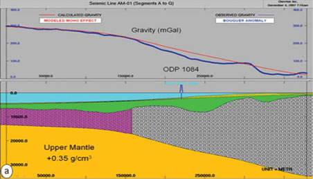


Advanced modeling exercise from Terraquest in which a model of mantle (yellow), oceanic crust (purple), continental crust (grey stippled) and overlying unconsolidated sediments. Modeling is used to derive parameters for each unit (image C) to verify starting model for further interpretation.
Applications
Terraquest’s clients for Equilibrium™ airborne gravity surveys are hydrocarbon and base metal explorers seeking answers to questions of where are sedimentary basins or dense base metals located.
Case Histories and Reference Information
For More Information
Terraquest would be pleased to discuss Equilibrium™ airborne gravity surveys and interpretation approaches with you, click below.